• Skip to primary navigation
  • Skip to main content
  • Skip to primary sidebar
  • Skip to footer
Lydon Solutions

Lydon Solutions

Construction Project Management Software Solutions

  • Construction Viz
  • Services
    • Business Consulting
    • Professional Services
    • Microsoft 365 Managed Services
    • Government Agencies
  • Company
  • Events
  • Blog
  • Careers
  • Contact
  • Search
  • Free Consultation
Show Search
Hide Search

Company Updates

Don't miss out. Receive blog updates on the latest Lydon Solutions company news, product updates, and much more by joining our mailing list today.

  • This site is protected by reCAPTCHA and the Google Privacy Policy and Terms of Service apply.
  • This field is for validation purposes and should be left unchanged.


Re-Imagining Construction Project Management Software

Company Updates | July 17, 2018

We built our new lineup of Construction Viz Apps for SharePoint and Office 365 on React, an innovative technology used by industry-leading disruptors like Facebook, Netflix, AirBNB and Dropbox. Here’s why.

Our new Construction Viz Apps for SharePoint and Office 365 will radically change what you expect from your construction project management software. You no longer have to settle for expensive and bloated software packages full of features you don’t need and will never use.

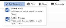
Construction Viz Apps let you select exactly the construction project management features you need—such as project status tracking, forms, GIS mapping, scheduling and more. Install the apps into your SharePoint 2013/2016 or Office 365 environment in minutes. You can use each app as a fully standalone solution or combine them into a powerful, feature-rich suite. There’s no steep learning curve, and it is simple to customize the apps to fit how you work.

Like I said, a radical departure from the status quo.

Helping make all this possible is React, a powerful technology at the heart of innovative web applications from companies like Facebook, Netflix, AirBNB and Dropbox.

How React Supercharges the Construction Viz Apps

But wait (you may very well ask). What does a technology that powers social media, streaming video, and vacation rentals have to offer construction project managers?

The answer is flexibility, scalability and speed.

React is a modern, open-source library of JavaScript components optimized for building user interfaces (UI). The technology was originally developed by Facebook and Instagram. That says a lot right there. Every time one of Facebook’s or Instagram’s two-billion-plus users logs in, the newsfeed processes dozens of data points to create a completely custom experience in real time. A big part of what makes this possible is React and the extremely efficient way it handles UI updates (e.g., the virtual DOM).

Another reason React is so powerful is its structure of reusable components. These components can be anything from small UI elements (e.g., a button, form, or menu) to entire features. Once built, these components can be used again and again, making a React codebase simple, modular, and easy to maintain.

So what does React bring to our Construction Viz Apps? Lots.

  • You can just buy the construction project management features you need now and add more later. Thanks to React’s component-based structure, each app works independently and can be combined with other apps for added functionality.
  • You can save money. The streamlined nature of coding in React enables us to keep our prices down to begin with. Plus, you buy only what you need, not some huge package.
  • You are always up to date. Because React is modular, we can update and add features quickly without affecting other components. So fewer bugs. Faster fixes.
  • You have incredible flexibly to customize your tools out of the box. This means your construction project management software will fit how you work and not the other way around.
  • You can work anywhere. Since React was built by Facebook and Instagram, it’s optimized by design for mobile devices, ensuring that each Construction Viz App is fully mobile responsive.
  • Lots of data? No problem. React was designed for web applications serving millions. This enables our Construction Viz Apps to handle massive data sets with ease while keeping the user experience snappy.
  • Integrations with enterprise applications like P6 and ArcGIS are a breeze. React makes it simple to interface with other systems, adding to the already impressive extensibility of SharePoint.
  • Forget the learning curve. We’ve used React to create a simple and consistent UI that carries across all the apps. And we’ve improved the administration and setting options, which makes it easier to configure elements of your SharePoint experience.
  • You are future proof. Construction Viz Apps are built on two modern technologies—React and SharePoint—which are supported by two technology goliaths, Facebook and Microsoft. You’re in good hands going forward.

Construction Project Management Software Designed for You

Our new Construction Viz Apps are gamechangers. No other solution gives you as much flexibility and control – not to mention how much money you will save by buying only what you need. Get a solution built on the latest technology and designed for you and how you work.

Contact us for a free consultation and demo to see the future of construction project management.

Construction Viz Adds New Mobile Doc Access and Real-Time Collaboration Features

Company Updates | November 13, 2017

We have integrated the powerful features of Office Online Server into Construction Viz. Now you can edit documents right from your mobile browser and collaborate in real-time with your team.

We built Construction Viz on top of Microsoft SharePoint 2016 so that our users can take advantage of the power and reliability of the Microsoft ecosystem. This means our clients not only get the best construction project management software tools out there, but they also benefit from everything Microsoft adds to their flagship products like Office, OneNote, and more.

The latest example: We’ve integrated Office Online Server with Construction Viz and the power of SharePoint 2016. The integration enables Construction Viz users to view and edit Office documents right from their mobile browser. It also lets them collaborate on documents in real-time on any device.

Let’s take a closer look at each new feature.

Native Cross-Browser Access to Documents on Mobile Devices

Thanks to our integration with Office Online Server, Construction Viz users can now view and edit Microsoft Office files – including Excel, Word, PowerPoint, and OneNote documents – directly in their native mobile browser.

Construction project teams spend a lot of time in the field. This feature lets remote team members access and edit project documents on their mobile devices without installing other apps.

No More Check-in, Check-out Editing

SharePoint includes document collaboration by default. But it can be a cumbersome process:

  • You had to checkout and download a document.
  • Then you made edits in your Microsoft Office desktop application.
  • Finally, you uploaded the document and checked it back in to SharePoint.
  • The next user then repeated the above steps to make their edits.

Not anymore. Our integration with Office Online Server now enables multiple users to simultaneously edit documents – either directly in their browser or using their local Microsoft Office application. Office Online Server and SharePoint track all changes made by users, so it is easy to see who made which edits and roll back to earlier versions if necessary.

This new collaborative editing feature is a huge timesaver allowing teams to simultaneously work together on project plans, procedures, specifications, presentations, and other communication documents. It also makes it much easier to collaborate with users across your organization – just invite them to edit the document.

And the collaborative editing feature also takes advantage of the native mobile browser support discussed above. Collaborators can thus view and edit the document on any device without installing any other software or apps.

See the screenshots below for a preview of how the new collaboration features enabled by Office Online Server work.

New options to edit in your Microsoft desktop application or in the browser:

Multiple users simultaneously editing the same document:

Viewing the edit activity for a history of changes by user:

Bringing the Power of Office Online Server and SharePoint 2016 to Construction Viz

The feedback from users after we integrated Office Online Server into Construction Viz has been great. It’s an eye-opening experience to see edits from multiple users show up in real-time in a document you are editing. We are excited how far this technology has come and how it will change the way team members collaborate in the future.

We look forward to hearing your experiences with Office Online Server and how it has made your team more productive in the comments below.

See what Construction Viz can do for you

Find out more about Construction Viz by visiting our microsite, or contact us to schedule a free consultation and demo.

Easily Integrate Geospatial Maps and Project Data with Construction Viz

Company Updates | February 17, 2017

“Dude, where’s my project?” is not something project teams should ever need to wonder. Integrating geospatial information into your PMIS solution enables you to combine project data with map data. For projects spanning multiple locations, this kind of insight is invaluable to project teams in your organization.

Geospatial mapping software, such as ArcGIS, provide interactive ways to display project information in the context of a map.  Seeing information geospatially is extremely helpful to project teams working on geographically dispersed engineering or construction projects. For example, oil and gas transmission and distribution projects.

Programs like ArcGIS enable the creation and consumption of geospatial maps. But project teams typically need these maps to also show content that isn’t available in ArcGIS such as documents, forms, videos, images, dashboards, and reports. The challenge is finding a way to update these content types geospatially, with all the great features ArcGIS provides, in a fully mobile UI.

Typical Methods of Displaying Geospatial Data for Construction Projects

We have implemented many solutions over the years for displaying geospatial data as part of SharePoint deployments for our clients. Each of the typical methods for adding map data to SharePoint has a niche application. But each came with one or more drawbacks:

Inline Frames – An Inline Frame (I Frame) is an HTML document or page embedded inside SharePoint.  The I Frame is linked to web pages with custom JavaScript.  While this approach works for any external content that you want to display inside SharePoint, the user experience is lacking. Maps displayed this way are also not responsive for mobile devices.

Third-Party Apps – There are some slick and affordable apps available for displaying mapping data and even incorporating SharePoint content into the maps. However, their flexibility and functionality are often limited.  For example, they are typically unable to connect to more than [SW1] [JL2] one SharePoint list and are not responsive for mobile devices. It is also a gamble to use them since many of these apps are rarely updated with enhancements and are not customizable.

Vendor Supported Apps – Since SharePoint is the #1 Enterprise Content Management System (ECM), many geospatial software vendors provide their own SharePoint apps.  These apps are great in that they can connect directly to the vendor’s software and allow for some SharePoint connections. But again, they are limited in functionality, cannot be enhanced, and are not responsive for mobile devices.

The above methods worked well enough to serve limited requirements, but the shortcomings left us wanting a better solution.

Which is why we decided to build a custom mapping solution for Construction Viz, our subscription-based construction project management platform.

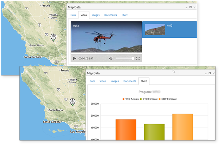
The Construction Viz Mapping Solution

We designed Construction Viz to provide tight integration between project data and geospatial information. We wanted our mapping toolset to be robust, flexible and responsive.

The Construction Viz mapping solution offers the following key benefits:

Robust Interconnectivity – The Construction Viz mapping solution connects to essential project information sources, including:

  • SharePoint – E.g. lists, form libraries, document libraries, image libraries, video libraries, etc.
  • SQL – Bi-directional data transfer between SharePoint and SQL allows data to be sent back to the SQL data warehouse from the map itself and updated from SQL directly (or staged via a SharePoint List).
  • ArcGIS – Direct connectivity with Esri’s ArcGIS Online enables live updates to layers and other content. Additionally, KML layers can be uploaded to a document library and displayed on maps via layers.

Flexible functionality and extensibility – The ability to change map behavior depending on project need is a critical business requirement.  Our mapping tool utilizes a JavaScript framework that we have incorporated across our Construction Viz and SQL solutions.  This framework ensures a consistent user experience across our SharePoint pages and web parts as well as SQL-based solutions.  Our primary goal was to anticipate how construction project teams would use the map data and provide this functionality in an easy to use and intuitive layout.

Responsive, mobile friendly design – Since Construction Viz is a mobile solution, we needed to make sure our mapping tools could be accessed on a mobile device with the same experience as being on a desktop.  We built the solution to work on IOS, Android, and Windows mobile devices.

Other features of the Construction Viz mapping solution include:

  • Custom filters (such as program and project) for querying large data sets
  • Clustering of large data sets
  • Custom layer queries (such as Over Budget, Behind Schedule, etc.)
  • KML layers
  • Pop up/click event windows for displaying data related to locations such as:
    • SQL Data for financial and schedule information
    • Video and images stored in image libraries
    • Documents stored in document libraries
    • Charts/Dashboards of project progress
  • Printing

Want Geospatial Map Data Integrated with Your Team’s Project Data?

Find out more about Construction Viz by visiting our microsite, or contact us to schedule a free consultation and demo.

Primary Sidebar

Recent Posts

Reviews | February 23, 2023

How AI-generated Images Like DALL-E2 Could Change Construction

How-To | February 16, 2023

The Great Metadata Convergence with Microsoft Teams, SharePoint, and OneDrive

Microsoft Teams Bulletin App
How-To | February 2, 2023

Keep Your Team in the Loop with the Microsoft Teams Bulletins App

ChatGPT Microsoft 365
Reviews | January 23, 2023

What Value Does Microsoft 365 Bring to an Organization? (According to ChatGPT)

How-To | January 16, 2023

Microsoft 365 OneDrive and Teams for Your Construction PMIS

How-To | January 6, 2023

What Microsoft 365 @mentions Mean for Construction Communications

Footer

About

Lydon Solutions is a WBE consulting group specializing in construction project management software solutions using Microsoft SharePoint. Learn more >

Products & Services

  • Construction Viz
  • Professional Services
  • Business Consulting
  • Microsoft 365 Managed Services
  • Government Agencies

News & Events

  • Events
  • Blog

Company

  • About
  • Careers
  • Contact Us

Join our Mailing List

  • This site is protected by reCAPTCHA and the Google Privacy Policy and Terms of Service apply.
  • This field is for validation purposes and should be left unchanged.
Lydon Solutions

© Lydon Solutions

  • Sitemap
  • Privacy
  • Cookies
  • Terms of Use
  • Disclaimer